Spatial Intelligence and Point Cloud
TECNALIA promotes LiDAR and 3D sending technology, and the result of these processes and technologies, which is the point cloud. TECNALIA understands that this technology offers the best perspective of the environment (dimensions, shapes, volumes, speeds, trajectories…), and a detailed understanding of that environment leads to multiple work flows of great value in several domains.
Spatial Intelligence at TECNALIA
There are two types of point clouds that are generated from LiDAR equipment:
- Static point clouds, which are “3D photos” of points, i.e. there is no movement in the points of the “3D photo”. This type of cloud is widely used in the construction industry, both in building and civil engineering.
- Dynamic point clouds, which are “3D videos” of points, i.e. they involve movement in the points of the “3D video”. These, however, are used more in autonomous mobility and robotics, as their perception systems.
What is the value of Spatial Intelligence?
The real value of Spatial Intelligence lies in adding 3 properties to this point cloud:
- Location, i.e. the absolute or relative position on a map
- Perception, i.e. gathering accurate information from the environment (colour, distance, speed, etc.)
- Semantics, i.e. making sense, understanding location and perception data (is it a vehicle at the roundabout, is it a person crossing…)
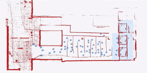
Object Detection allows us to identify and count objects. This can lead to multiple additional tasks, such as automated BIM modelling.
Object Tracking allows us to analyse trajectories, velocities, flows… This can lead to services such as: Waiting times and delays; capacity, queues and occupancy; excessive/defective speed; measurements and classification, etc.
Target audience
- Architecture Studios
- Engineering Firms
- Construction Companies and Developers
- Public Administrations